GPS Features
GPS features of the camera can be used to geotag images, set the time, and more. The camera can receive signals from GPS satellites (USA), GLONASS satellites (Russia), and the Quasi-Zenith Satellite System “Michibiki” (Japan).
Caution
-
Geotag information may not be recorded or inaccurate information may be recorded where GPS signal coverage is poor, such as in the following places.
- Indoors, underground, near or between buildings, in tunnels or forests
- Near high-voltage power lines or mobile phones operating on the 1.5 GHz band
- When the camera is carried in a bag or other container
- When traveling long distances
- When traveling through different environments
- Even in conditions other than these, GPS satellite movement over time may interfere with geotagging and cause missing or inaccurate geotag information. The information may also indicate that the camera was used along a route even if it was used at one location.
- Elevation is not as accurate as latitude or longitude, due to the nature of GPS.
- Inside the camera, the GPS antenna is near the front of the hot shoe. Although GPS signals can also be acquired with a Speedlite attached, acquisition sensitivity will be slightly lower.
- When carrying the camera in a bag or other container, make sure it is face-up with nothing covering it.
- Set the camera time and date as accurately as possible. Also set the correct time zone and daylight saving time for the shooting location.
- Fewer shots are available in locations with poor signal coverage.
- Remaining battery capacity may be lower when GPS features are used. Charge the battery as needed, or consider purchasing a spare battery (sold separately).
- Others may be able to locate or identify you by using information in your geotagged still photos or movies. Be careful when sharing these images with others, as when posting images online where many people can view them.
GPS Settings
-
Select [
 : GPS settings].
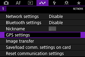
-
Configure GPS details.
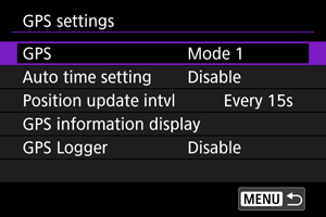
[GPS]
Specify the GPS operating mode.
- In [Mode 1], the camera continues to acquire GPS signals at regular intervals with the power switch set to
 or even
  .
. - In [Mode 2], the camera acquires GPS signals with the power switch set to . Setting the power switch to also deactivates GPS features. Note that after auto power off is activated, the camera continues to receive GPS signals at regular intervals.
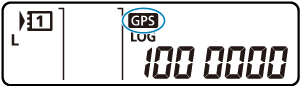
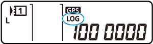
When acquiring GPS signals, use the camera outdoors where the sky is unobstructed and aim it up, keeping your hand and other objects off the top. Signal acquisition under favorable conditions takes approx. 30–60 sec., and then [![]() ] is lit on the rear LCD panel or screen.
] is lit on the rear LCD panel or screen.
Shots taken when [![]() ] is lit are geotagged.
] is lit are geotagged.
Caution
- When [Mode 1] is set, the camera continues to acquire GPS signals at regular intervals even with the power switch set to , which drains the battery faster and reduces the number of shots available. Set to [Disable] if you will not use the camera for some time.
- If auto power off continues for an extended period in [Mode 2], the battery will be drained faster and fewer shots will be available. Set the power switch to if you will not use the camera for some time.
[Auto time setting]
Time information acquired from GPS signals can be set on the camera. The margin of error is approx. ±0.02 sec. Selecting [Auto update] will update the time when GPS signals are received while the camera is on.
Caution
- The time cannot be automatically updated unless signals from at least five GPS satellites can be acquired. [Set now] will be grayed-out and unavailable.
- Even if [Set now] can be selected, time adjustment may not be possible, depending on the timing of GPS signal acquisition.
- Setting [Auto time setting] to [Auto update] prevents the date or time from being manually set with [
 : Date/Time/Zone] ().
 - If you have performed [Sync time between cameras] and prefer not to have the time adjusted, set [Auto time setting] to [Disable].
[Position update intvl]
You can set the positioning interval (time) for updating geotag information. Although tagging is more accurate when the geotag information is updated at shorter intervals, this reduces the number of shots available because it drains the battery faster.
Caution
- Some inconsistency in positioning intervals is inevitable, due to the nature of GPS.
[GPS information display]
Shows acquired GPS information.
The ![]() icon indicates signal conditions. When [
icon indicates signal conditions. When [![]() ] is displayed, elevation is also recorded. Note that elevation is not recorded when [
] is displayed, elevation is also recorded. Note that elevation is not recorded when [![]() ] is displayed.
] is displayed.
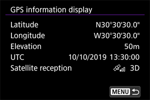
You can check geotag information by displaying a shot, pressing the ![]() button to access the shooting information screen, and then pressing
button to access the shooting information screen, and then pressing ![]() .
.
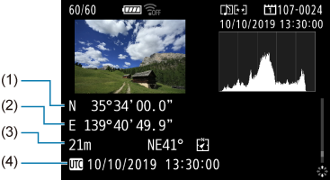
- (1) Latitude
- (2) Longitude
- (3) Elevation
- (4) Coordinated Universal Time (UTC)
Note
- Movies are tagged with the geotag information acquired when you start recording. Note that signal reception conditions are not recorded.
- Coordinated Universal Time, abbreviated as UTC, is essentially the same as Greenwich Mean Time.
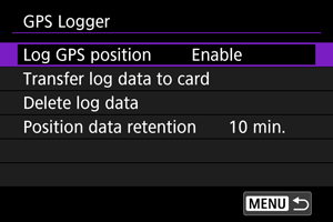
GPS Logger
By setting [Log GPS position] to [Enable], you can automatically record geotag information at specific intervals along the route that the camera travels. Geotag information is recorded at the interval set in [Position update intvl] as log data saved in the camera's internal memory by date. You can also view the route traveled on a map displayed on a computer.
Position update intervals and log data capacity (in days) are as follows.
| (Approx.) | |||
| Update Interval | Log Data | Update Interval | Log Data |
|---|---|---|---|
| Every sec. | 4.1 days | Every 30 sec. | 100 days |
| Every 5 sec. | 20 days | Every min. | 100 days |
| Every 10 sec. | 41 days | Every 2 min. | 100 days |
| Every 15 sec. | 61 days | Every 5 min. | 100 days |
With one day being equivalent to eight hours of log data
- Names of daily log files consist of the date and number (such as 19101000). New log file are created if the camera enters a new time zone ().
- When the camera's internal memory becomes full, old log data is overwritten with new data.
Caution
- In [Mode 1], GPS logging continues even with the power switch set to .
- In [Mode 2], setting the power switch to deactivates GPS logging. However, GPS logging continues during auto power off.
- Geotag information added to images may be inaccurate under some traveling conditions, in some locations, or under some GPS settings.
Transferring log data to a card
You can transfer recorded log data to a card selected in [Transfer log data to card].
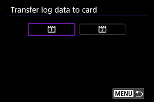
- Transferring log data to a card erases the data from the camera's internal memory.
- Log files transferred to a card are stored in the “GPS” folder within the “MISC” folder. They are saved with a “.LOG” file extension.
- Log files (.LOG) can be converted to KMZ format with GPS Log File Utility ().
Deleting log data
To delete log data in internal memory, select [Delete log data], then select [OK]. It may take approx. 1 min. to delete the data.
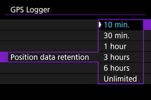
Position data retention
To continue geotagging images even where satellite coverage is poor (if you go indoors, for example) by using geotag information in log data, setting [Position data retention] to [Unlimited] is recommended. The most recently acquired geotag information is added to log data until new information can be acquired.
When a time such as [10 min.] is set, after geotag information cannot be acquired, the most recent geotag information is added to log data for the specified period.
GPS Precautions
Countries/regions permitting use of GPS functions
Use of GPS features is restricted in some countries and regions, and illegal use may be punishable under national or local regulations. To avoid violating GPS regulations, visit the Canon website to check where use is allowed.
Note that Canon cannot be held liable for any problems arising from use of GPS functions in other countries and regions.
- Because the use of GPS may be restricted in some countries and regions, follow local laws and regulations where you will use the camera. Be particularly careful about using GPS functions outside your home country.
- Be careful about using GPS functions where the operation of electronic devices is restricted.
- Others may be able to locate or identify you by using location data in your geotagged still images or movies. Be careful when sharing these geotagged still images, movies, or GPS log files with others, such as when posting them online where many people can view them.
- GPS signal reception may take a longer time in some cases.