Creating a Registered Map
When MREAL will be experienced in the same MREAL space repeatedly, you can increase the stability of camera tracking by creating a registered map.
Press button <A> of the MREAL Display, select [] in the displayed menu, and select an item.
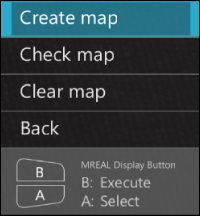
The menu displayed by pressing button <A> of the MREAL Display can also be displayed by clicking [![]() ].
].
-
With [], create a registered map centered on the MREAL user who looks around to observe the 3D CG.
-
With [], create a registered map for the MREAL user to move around to observe the 3D CG.
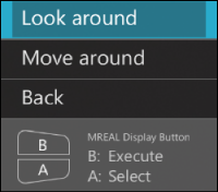
Looking Around
-
When [Fix the position of the canvas.] appears, wait at the position (start point) to view the 3D CG.
-
Press button <A>, select [], and press button <B>.
-
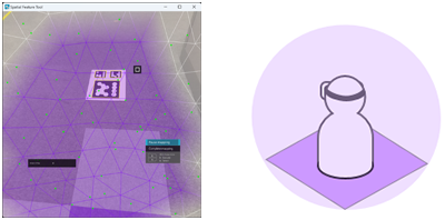
Map around the start point.
-
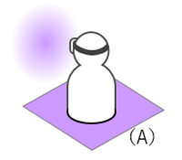
A purple square (A) to indicate the position of the “canvas” (the range in which mapping will occur) is displayed at the feet of the user.
-
Look around within the range of the square at your feet to perform mapping so that the entire canvas turns purple.
-
-
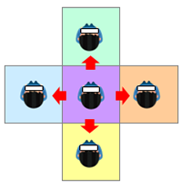
Map the area to the front, back, left, and right of the start point.
- Move forward, backward, leftward, and rightward from the mapping start point. When you move within the canvas, the color of the square at your feet changes.
-
Look around within the range of the square at your feet to perform mapping so that the entire canvas becomes the color of the square.
-
Register the map.
- When mapping is finished, press button <A>, select [], and press button <B>.
- When the [Register map] message appears, select [Yes] and press button <B>.
- Press button <B> on the MREAL Display or press the [Esc] key of the PC to end Spatial Feature Tool.
Note
- Perform mapping of areas other than the starting point as necessary.
Moving Around
-
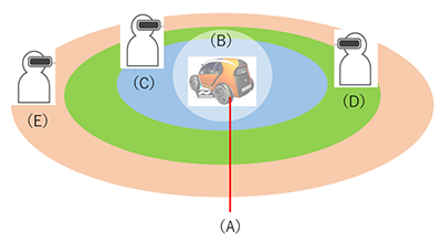
Map the close range (C).
- When [Fix the position of the canvas.] appears, align the center of the sphere indicating the canvas (position to display the 3D CG: B) with the position to display the 3D CG (A).
-
Move to the front/back of the sphere to determine the size of the canvas, and press button <B>. The area seen in the MREAL Display is recognized as the mapping data and displayed in blue in the image.

- Perform mapping so that the entire canvas turns blue while moving the range of the canvas.
-
Map the medium range (D).
- Move away from the canvas until green is displayed. Perform mapping so that the entire canvas turns green while moving the range of the canvas.
-
Map the far range (E).
- Move away from the canvas until orange is displayed. Perform mapping so that the entire canvas turns orange while moving the range of the canvas.
-
Register the map.
- When mapping is finished, press button <A>, select [], and press button <B>.
- When the [Register map] message appears, select [Yes] and press button <B>.
- Press button <B> on the MREAL Display or press the [Esc] key of the PC to end Spatial Feature Tool.
Checking the Registered Map
If you press button <A> on the MREAL Display, select [], and press button <B>, you can check the status of the registered map.
-
If there is an unmapped area, select [] and press button <B>.

- Add feature points, etc. and then perform mapping.
- When mapping is finished, press button <A>, select [], and press button <B>.
When to Delete the Registered Map
In the following cases, delete the registered map and then create a new registered map.
- When the position of the world coordinate system has been changed
- When there is a map that was created in another environment
- When the features in the space have changed significantly
-
Select [Spatial Feature] in [Basic Settings] of the MREAL Configuration Tool window.
-
Click [Detailed Settings].
-
Select [Delete] in [Registered Map Information] on the [Spatial Features] tab.
-
Select [Yes] in the displayed window.
-
Click [OK] at the bottom of the [Spatial Features] tab.